Mike
Well-Known Member
Interstate 29 is under close watch
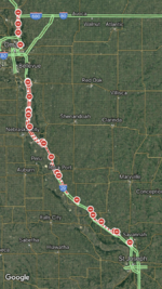
One lane of Interstate 29 is open north of St. Joseph Mo., following flash flooding that closed the interstate overnight.
However, the interstate is being closely watched in several locations as flooding threatens the lanes.
If you choose to use I-29, please pay close attention to message boards, local media and/or stay in close contact with someone who can relay messaging from MoDOT. Due to the nature of the situation, closure messages are likely to have little to no forewarning.
Should you learn about a closure when beyond the closure point, please turn around at the next safe, accessible overpass and resume use of the flood detour route.
The US 36 bridge to Kansas at St. Joseph, Mo., is open at 9:45 am, Wednesday. All westbound bridges north of that point are closed due to flooding.
Flood Detour Route
I-35 N from Kansas City to
I-80 West in Des Moines to
I-29 at Sioux City, South Dakota
OR
US 71 into Iowa
and vice-versa.
Find road conditions information for all of Missouri's bordering states athttps://www.modot.org/road-conditions-missouris-surrounding-states
Find the locations of Missouri highway closures using the MoDOT Traveler Information Map at http://traveler.modot.org/map/. You can also use the free mobile map app, available by searching for "MoDOT" on Apple or Google Play app stores.
Both the website and the app have a zoom function that allow you to narrow your search to specific areas and highways.
Be safe. Stay dry.

